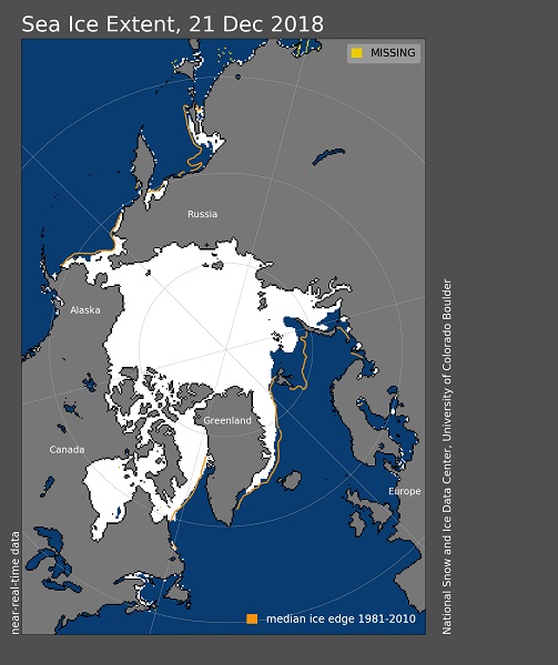
December 21st, 2018: Arctic sea ice extent ***********************
Autumn freeze-up amps up
The Arctic freeze-up season is well underway, with ice extent increasing faster than average for most regions in November. Exceptions were in the Chukchi and Barents Seas, where the ice has been slow to form. November snow cover over North America was the most extensive since 1966.
Arctic sea ice extent for November averaged 9.80 million square kilometers (3.78 million square miles). This was the ninth lowest November in the 1979 to 2018 satellite record, falling 900,000 square kilometers (347,000 square miles) below the 1981 to 2010 average, yet 1.14 million square kilometers (440,000 square miles) above the record November low in 2016.
Sea ice extent increased quite rapidly during the early part of the month, bringing the extent within the interdecile range of the 1981 to 2010 climatology during the latter half of the month. This was due in part to the Laptev Sea finally freezing up after having extensive open water through the end of October, as discussed in our previous post. There was also considerable ice growth in Hudson Bay, Baffin Bay, the Chukchi Sea, and the Kara Sea. This rapid growth is not particularly surprising. As the sun has set in the Arctic, the atmosphere has strongly cooled. As soon as the remaining open ocean water loses its heat to the atmosphere, ice growth occurs. Further, the increased area of open water in summer had led to increased frequency of rapid ice growth events in mid to late autumn, in which more than 1 million square kilometers (386,000 square miles) of ice can form within a 7-day period (see Stroeve and Notz, 2018).
Despite relatively fast ice growth during November, at the end of the month substantial open water still remained in the Chukchi and Barents Seas. The Chukchi Sea was in general completely ice covered by the end of November in the 1980s through to the early 2000s. However, low ice extent in the Chukchi Sea into late autumn has become quite common in recent years and this year’s extent is comparable to the new normal for this time of year in the region. Similarly, in the Barents Sea, low autumn extent has become common in recent years as warm Atlantic water is preventing ice growth farther north—a process called “Atlantification.”
Air temperatures at the 925 mb level (about 2,500 feet above the surface) were modestly above average in November across most of the Arctic Ocean (up 2 degrees Celsius or 4 degrees Fahrenheit), the main exception being slightly cooler than average conditions in the Laptev Sea (Figure 2b). Average low sea level pressure centered over the Siberian coast of the Kara Sea, a pattern tending to draw in cold continental air from Siberia over the Laptev Sea. By contrast, temperatures were up to 4 degrees Celsius (7 degrees Fahrenheit) above average over the East Greenland Sea and extending east over Scandinavia. It was also quite warm, up to 6 degrees Celsius (11 degrees Fahrenheit), over the interior of Alaska
Overall, sea ice extent during November 2018 increased 3.08 million square kilometers (1.19 million square miles). This is 994,000 square kilometers (384,000 square miles) greater than the 1981 to 2010 average November extent increase. The linear rate of sea ice decline for November is 53,500 square kilometers (21,000 square miles) per year, or 5.0 percent per decade relative to the 1981 to 2010 average.
Image courtesy of the National Snow and Ice Data Center, University of Colorado, Boulder (https://nsidc.org/arcticseaicenews/). Data source see http://nsidc.org/arcticseaicenews/about-the-data/