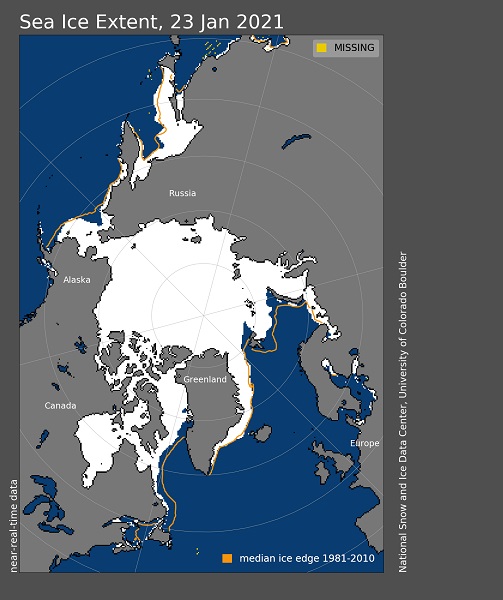
January 23th, 2021: Arctic sea ice extent ***********************
The Arctic climate was extraordinary in 2020, but the year ended with a less spectacular December. Ice growth was faster than average throughout the month, but extent at month’s end remained among the lowest in the satellite record. Air temperatures for the month were higher than average in most areas, but less so than in many previous months. Overall, it was an extremely warm 2020, especially over Siberia.
Arctic sea ice extent averaged for December 2020 was the third lowest in the satellite record. The monthly average extent of 11.77 million square kilometers (4.54 million square miles) was 1.07 million square kilometers (413,000 square miles) below the 1981 to 2010 December average. Sea ice cover was below average in the Bering Sea on the Pacific side and the Barents Sea on the Atlantic side. Compared to 2016, which had the lowest December sea ice extent on record, the ice edge in 2020 is further south in the Barents and East Greenland Seas, but further north in Davis Strait and the Labrador Sea.
Conditions in context
Sea ice extent increased by 2.71 million square kilometers (1.05 million square miles) during the month of December. This was greater than the 1981 to 2010 average gain in December of 1.99 square kilometers (780,000 square miles). However, after a rapid early and mid-month gain, the rate of extent increase slowed considerably (Figure 2a).
December air temperatures at the 925 mb level (about 2,500 feet about sea level) continued to be relatively high for this time of year over much of the Arctic Ocean, particularly north of the Laptev and East Siberian Seas, which saw temperatures of 5 degrees Celsius (9 degrees Fahrenheit) above the 1981 to 2010 average (Figure 2b). Average and below average temperatures prevailed in the Beaufort and eastern Chukchi Seas.
The Arctic Oscillation (AO), after being in a strong positive mode for most of November, flipped to a negative mode for most of December. As a result of the AO flipping to negative, a sea level pressure pattern formed in December with high pressure over the Arctic Ocean, a fairly strong Beaufort Sea High pressure pattern, and low pressure over the Atlantic and Pacific subarctic. Earlier research (Rigor et al., 2002) argued that during winter, a negative mode tends to retain older and thicker ice within the Arctic Ocean, which potentially portends a more moderate ice loss the following summer. Conversely, when the AO is positive, the wind pattern helps to transport ice from the Siberian coast, across the pole and out of the Arctic Ocean via the Fram Strait, leaving more thin ice along the Siberian shore that melts out readily in summer. The strong positive AO during the winter of 2019 to 2020 may have played a role in this past summer’s low sea ice extent. However, this relationship between the AO and summer ice extent has not been strong in recent years.
Image courtesy of the National Snow and Ice Data Center, University of Colorado, Boulder (https://nsidc.org/arcticseaicenews/). Data source see http://nsidc.org/arcticseaicenews/about-the-data/