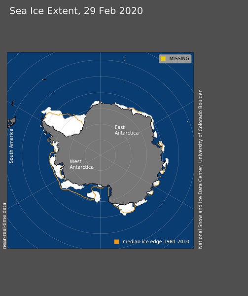
February 29th, 2020: Antarctic sea ice extent ***********************
A positively persistent, persistently positive Arctic Oscillation: Sea ice extent for February 2020 tracked below average, ranking as the thirteenth lowest monthly average in the satellite record. A brief pause in ice growth in the middle of February was related to the regional wind pattern. As has been the case for the past several months, the Arctic Oscillation was in a persistently positive phase. This manifested as unusually low sea level pressure over the Atlantic side of the Arctic Ocean and high pressure over Eastern Eurasia, extending eastward into Arctic Canada. Arctic sea ice extent for February 2020 was 14.68 million square kilometers (5.67 million square miles), the thirteenth lowest in the satellite record. This was 620,000 square kilometers (239,000 square miles) below the 1981 to 2010 February average and 710,000 square kilometers (274,000 square miles) above the record low mark for February set in 2018. At the end of February, ice extent was below average over parts of the Barents and Kara Seas, and the eastern Greenland Sea. Nearing the minimum in the south: As of February 20 and 21, Antarctic sea ice extent likely reached its annual minimum at 2.69 million square kilometers (1.04 million square miles). However, as of March 1, sea ice extent has increased only marginally above the minimum value, to 2.71 million square kilometers (1.05 million square miles). The latest Antarctic minimum over the satellite record was March 3. We anticipate that sea ice will continue to expand as late summer and autumn proceed. At this time of year, Antarctic sea ice cover is characterized by a number of small remnant patches of ice around the coast, with the largest being the western Weddell Sea and the Amundsen-Ross Sea coastal area. Overall sea ice remains below the 1981 to 2010 average, a trend that has persisted since September 2016. Sea ice extent in the Weddell area is near average overall, while ice extent in the Amundsen-Ross region is well below average. However, a patch of sea ice in the Pine Island Bay region is hampering research vessels in the area seeking to study ice-ocean interaction near some of the very large and rapidly changing glaciers draining the West Antarctic Ice Sheet.
Image courtesy of the National Snow and Ice Data Center, University of Colorado, Boulder (https://nsidc.org/arcticseaicenews/). Data source see http://nsidc.org/arcticseaicenews/about-the-data/